OIL SPILL RESPONSE PLANNING, TRAINING & EXERCISES

Contingencies has a wealth of experience in exercise design and facilitation. Formats range from relatively small, discussion-based exercises to large-scale, operations-based drills involving hundreds of participants.
Exercise design
consistent with Homeland Security Exercise & Evaluation Program (HSEEP) principles
Stakeholder outreach
joint exercise planning with federal/state agencies, local emergency responders, NGOs, industry partners, and OSROs
Expert facilitation
addressing major aspects of an oil spill response, in concert with the Planning “P”
Practical coaching
sharing our vast experiences with ICS and oil spill best practices
Constructive evaluation
including After Action Report (AAR) preparation
Grab the popcorn!
imaginative, yet realistic, our scenarios typically read like a Hollywood movie script, engaging participants right from the start
Challenging injects
unique to your operations and environmental setting (not database-generated), incorporating topics relating to safety, public information, stakeholder relations, operations, wildlife/environment, logistics, finance, claims, etc.
Play space setup
• ICS form kits
• dry-erase status boards
• laminated maps
• functional display signs/banners
• ICS position-specific vests
• GIS software
Participant manuals
professionally crafted in an easy-to-read format
Budget-conscious
cost-effective programs, catered to your budget
Our equipment deployment exercises are led by industry professionals with years of experience in oil spill response. Sessions may be conducted independently or as an operational component of a concurrent tabletop/functional exercise.
Boom deployment
practice techniques in your own “backyard”, at strategic locations identified in your OPA ’90 Spill Response Plan and governing ACP/GRP
Boom configurations
• containment
• diversion
• deflection
• exclusion
Hands-on instruction
• mooring line assembly
• towing and anchoring
• decontamination
• proper storage
• inventory rotation
• (most importantly) safety
Boom failure analysis
• entrainment
• splashover
• submergence
• planing
• drainage
Beyond booming
• underflow dam construction
• sorbent filter fence installation
• portable skimmer operation
• sorbent application
• temporary storage of oily liquids
• quick shoreline assessment
• staging area management
Through such platforms as Microsoft Teams, Cisco Webex, and Zoom, Contingencies can strategically design and facilitate an immersive virtual exercise session for members of your incident management team.
Meticulously planned and executed
customized to your specific organizational needs
Aptly facilitated discussions
accompanied by slide presentations to further engage participants and encourage dialogue
Modular format
session-oriented, with orchestrated meetings/briefings as part of the ICS Operational Period Planning Cycle
Breakout rooms
serving as forums for in-depth discussions among the respective ICS sections
Document sharing
real-time ICS form collaboration with your peers
Common operating picture
unique mapping interface allows exercise participants to collaborate on a dynamic situation map
Personalized “buckets”
creative means to assign tasks and deliver scripted injects to exercise participants
Electronic file library
• Exercise Plan (ExPlan)
• industry/government plans
• facility/pipeline diagrams
• fillable ICS forms
• ICS job aids
• slide presentations
• after action reports, etc.
As opposed to a multi-hazard approach, our classroom-style incident management training focuses on ICS principles as they specifically apply to oil spill response.
Rich in visual aids
photographs, illustrations, example ICS forms, and case histories form the “backbone” of our training presentations
Customized handbooks
serve not only as a training supplement, but also as a valuable post-training reference
Familiar ICS concepts
• common terminology
• position titles
• modular organization
• chain-of-command
• manageable span-of-control
• integrated communications
• management by objectives
• incident facilities
• Unified Command
• resource management
Emphasis on the Planning “P”
• ICS forms preparation
• meetings and briefings
• incident action planning
Beyond ICS
• oil spill containment/recovery
• sensitive area protection
• waste management
• shoreline cleanup
• equipment decontamination
• vessel decontamination
• submerged oil recovery
• wildlife rescue and rehabilitation
Local flavor
programs delve into relevant subject matter from your OPA ’90 Spill Response Plan and Area Contingency Plan (ACP), while also exploring local political and news media influences, public and environmental exposures, and site-specific operational and logistical challenges
ICS position-specific training
we also offer in-depth courses, focused on your specific role in the Command & General Staff
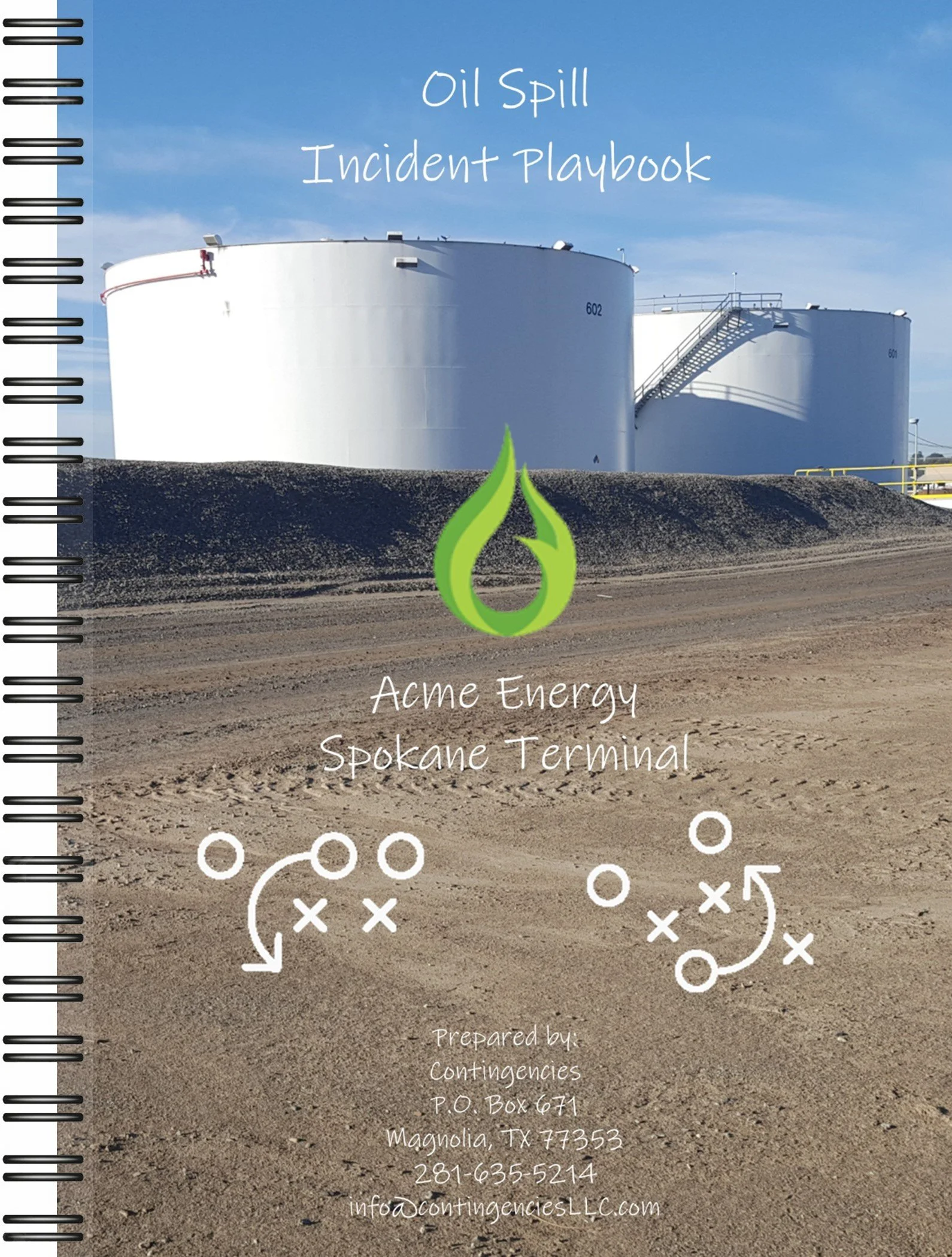
Bigger isn’t always better! Incident Playbooks streamline content and key elements from your regulatory plans into a convenient, miniature booklet.
Patterned as a composition notebook
with contents printed on glossy 5-inch x 7-inch pages, then assembled with wire O-ring binding
”Just the facts, ma’am”
in crisis mode, nobody has time to flip through countless pages of fine print, confusing flowcharts, and intricate matrices.
Reads like an “old-fashioned” recipe book
quick-reference checklists in bullet-point format, with a typeface and font that’s easy to read
Logical, step-wise format
organized by the sequence of events typically encountered in a well-executed spill response
Personal notepad
use it to record personal actions, important decisions, and significant events while responding to an emergency
Fill-in-the-blank forms
includes those forms applicable to the initial response, including Spill Notification Log, ICS-201, and the first evolution of the Site Safety & Health Plan, among others
Site-specific maps and diagrams
well of course!
Example pages
refer to the side panel for a few example pages, relating to a facility in Spokane, WA
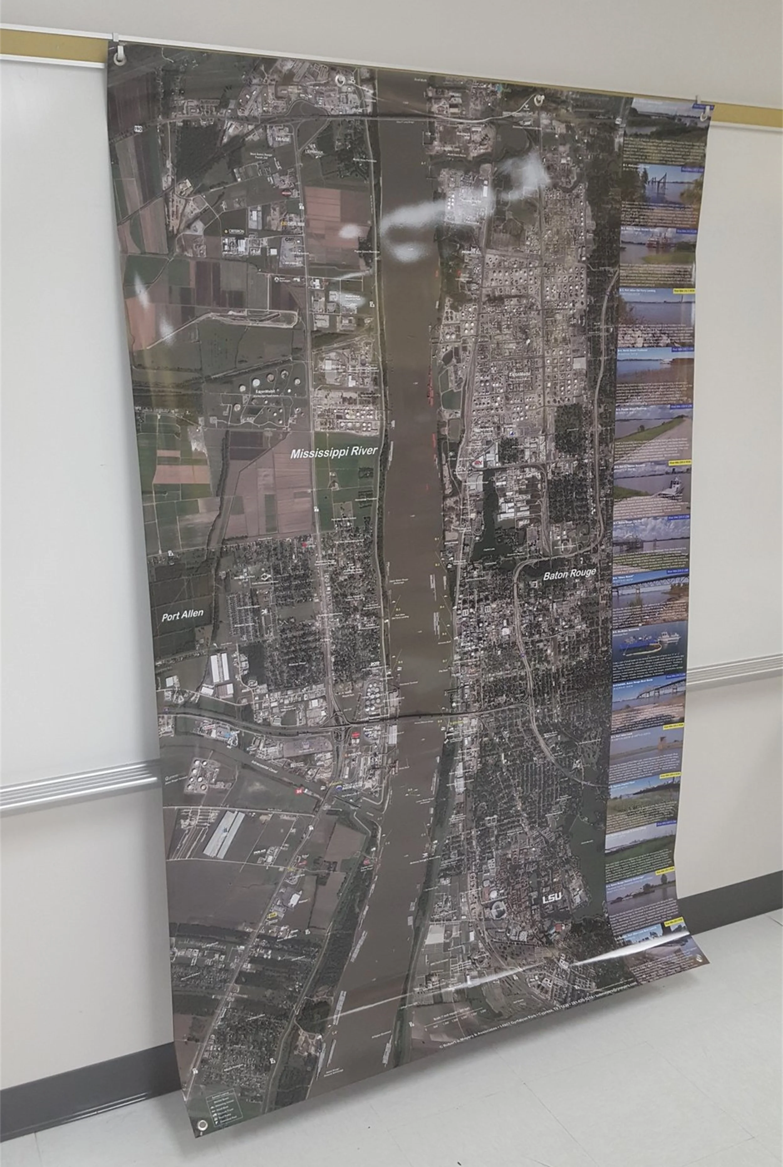
Photo flip books offer tactical guidance in a distinctly unique format, combining high-resolution aerial imagery with easy-to-interpret deployment instructions. We like to refer to them as “mini” Geographic Response Plans (GRPs)!
Field-ready
rigorous design features laminated or water-resistant pages, finished with wire-O binding
Painting the picture
layout promotes quick and effective decision-making, using illustrations as the primary means to communicate work instructions
Image overlays, without any clutter
• boom configurations
• anchoring mechanisms
• vacuum truck/skimmer positioning
• shoreline/terrain profiles
• tidal current/streamflow regimes
• property ownership
• physical site hazards
• public exposures
• indigenous flora/fauna
• prominent landmarks
• access routes
(not too) Technical writing
strategies and tactics generally stated in the form of a command, beginning with an action verb, allowing response personnel to have a clearer understanding of their specific work assignments
Simple spreadsheet of recommended resources
identifying the proper equipment, supplies, and personnel to successfully accomplish each task
GRP +
booklets incorporate tactical response strategies above and beyond the GRP, unique to your operations and environmental setting
Pick a size
5-inch x 7-inch or 7-inch x 10-inch, allowing for convenient storage in a vehicle’s glove compartment, boat’s storage console, dock house, supply trailer, spill kit, briefcase, backpack, etc.
Example pages
scroll through the side panel for a few example pages, featuring projects in Baton Rouge, LA, Mobile, AL, Tampa, FL, Portsmouth, NH, and Richmond, CA
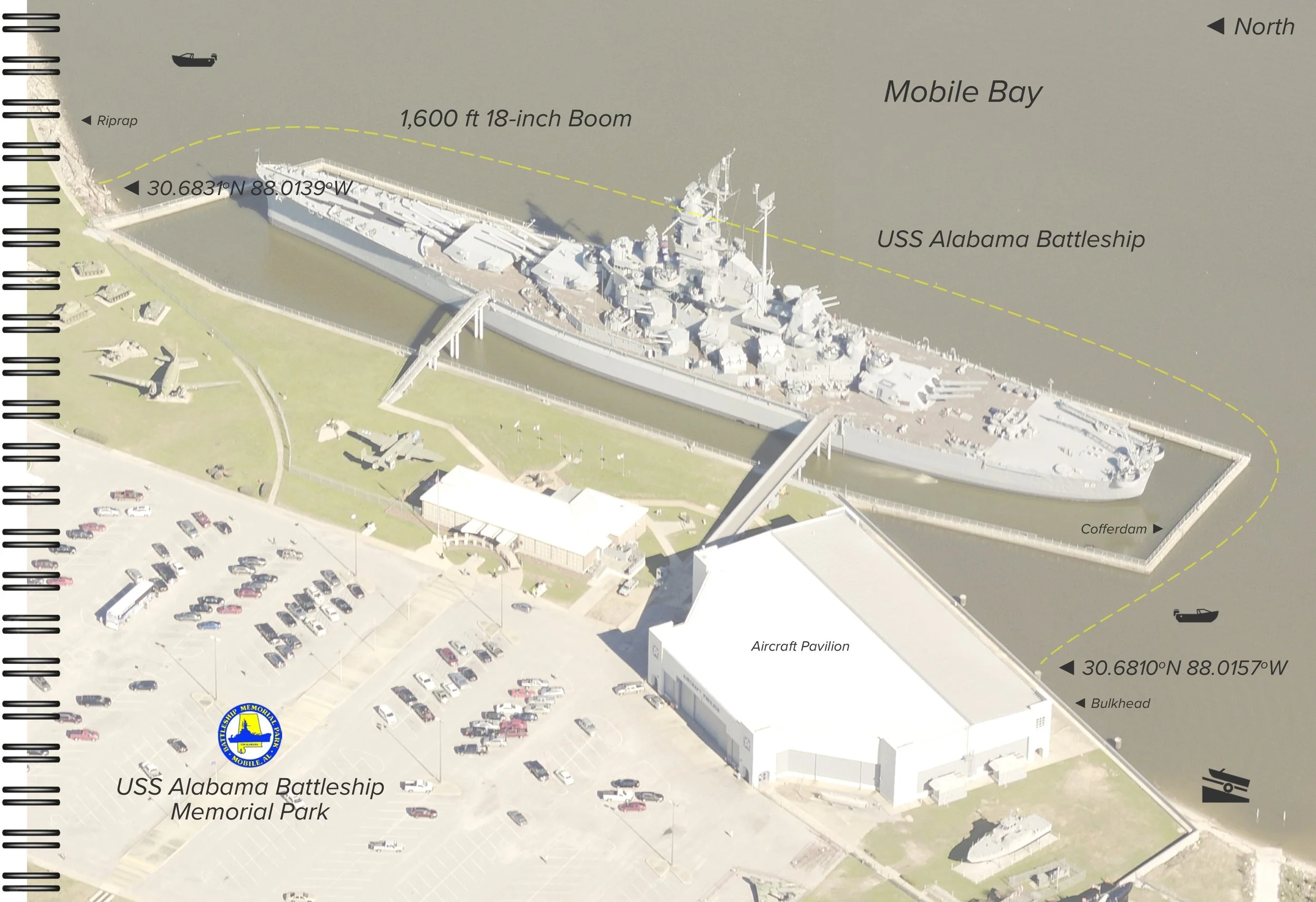
Your oil spill tactical plan doesn’t necessarily have to be in a 3-ring binder. Instead, envision your plan in the form of a vibrant poster display, at the center of strategic discussions as a pollution response unfolds.
”Eye-catching” graphics
printed on a durable, vinyl-type banner, then finished with glossy lamination, allowing notations to be made with a dry/wet-erase marker
High-resolution, aerial imagery
from either a vertical or panorama perspective
Work assignments
cleverly incorporated onto the posters, with a site photograph and brief narrative describing each proposed strategy
Sensitive areas prominently featured
• wetlands
• critical wildlife habitats
• parks/recreational areas
• marinas/boat basins
• water intakes
• residential neighborhoods
• industrial/port facilities
• commercial businesses
• hospitals/nursing homes
• historical/archaeological sites
• natural heritage areas
• groundwater recharge zones
• prime agricultural lands, etc.
Write-on/Wipe-off
• plot spill trajectories
• illustrate shoreline impacts
• track deployed resources
• outline Division boundaries
• demarcate hot zones
• note incident facilities:
◦ command posts
◦ staging areas
◦ interim waste storage areas
◦ decontamination stations
◦ medical first-aid stations
◦ wildlife triage centers
◦ air monitoring stations
◦ helipads, etc.
• depict wildlife impacts
Dynamic situation map
integral component of the Situation Display, effectively serving as the Common Operating Picture (COP) prior to the arrival of GIS technology
Custom sizes (large)
up to 5-feet high x 10-feet wide, optimized for use in a conference room setting, e.g., Incident Command Post (ICP)
Custom sizes (small)
miniature versions (24-inch x 36-inch) designed for field applications, spread out atop the hood of a pickup truck or rigged to the side of a boom/supply trailer
Examples
check out a few examples (and detailed content) in the side panel, from projects in Tampa, FL, Baton Rouge, LA, Martinez, CA, Mobile, AL, and Houston, TX
Assignment Lists (ICS-204) may be the most recognizable and standardized method to communicate work assignments to field personnel. It only makes sense to incorporate your oil spill tactical plan into this widely accepted format.
Bi-fold, brochure-type format
digitally printed on 80-lb card stock (both sides), with overall dimensions of 8.5-inch x 17-inch
Grab-and-go
may be conveniently stored in a canvas saddle bag, desktop acrylic file sorter, or 3-ring binder, ready for immediate use in an emergency
Pre-completed ICS-204
cover page features the all-important Assignment List (ICS-204), pre-loaded with clear-cut work instructions, resource needs, and site-specific safety and environmental concerns
Behold the centerfold!
folder opens to an impressive, oversized aerial photograph, depicting the site layout and boom arrangement
Overview map + site photograph
back cover includes a handy street map (or nautical chart) and representative photograph of the worksite
e-Spill Kit is our shiny new, web-based, oil spill mapping application. It’s the “all-encompassing” oil spill tactical plan, combining many of our popular formats into one.
A map to get excited about!
colorful collection of map pins serves as a springboard to a wide array of oil spill response-related data
Pop-up boxes
expertly laid out in a “stacked” arrangement, without any confusing geodatabase fields, integer codes, or other computer jargon
Work assignments
simply point-and-click on featured pushpins for a brief explanation of each strategy, accompanied by a boom schematic, equipment summary, photographs, and link to a printable version of the Assignment List (ICS-204)
Resources at risk
in-depth characterizations of sensitive receptors which could be negatively affected by a spill, through either direct contaminant exposure, public health/safety concerns, or business interruption
Incident facilities
location recommendations for command posts, staging areas, temporary waste storage areas, equipment/vessel decontamination stations, and wildlife triage centers
Telephone # dialing prompts
for local emergency responders, neighboring businesses and property owners, OSROs, and other stakeholders
Hyperlinks
providing quick access to weather forecasts, tide predictions, river gauge observations, ESI maps, ACPs, GRPs, and more
User-friendly (we mean it)
spill managers and field responders don’t have to worry about navigating a potentially intimidating GIS interface
Multi-platform
looks equally great on a variety of devices, including desktop/laptop computers, tablets, and smart phones
Real-time collaboration
with the appropriate credentials, editing and real-time collaboration amongst multiple simultaneous users is possible, allowing the platform to function as the Situation Map or Common Operating Picture (COP) in a training exercise or actual incident
Seeing is believing
contact us to schedule an online demonstration, featuring an up-close look at this unique oil spill planning and response tool
We fully understand plan maintenance can be a chore (and a bit of a bore). Let us help you remain in compliance, whether it’s preparation of a brand new plan from scratch, agency resubmittal of your existing plan, or assistance with minor (or major) edits following an annual review or regulatory audit.
Facility Response Plans (FRP)
Marine Transportation-Related Facilities (33 CFR 154),
Non-Transportation-Related Onshore Facilities (40 CFR 112),
Onshore Oil Pipelines (49 CFR 194)
Vessel Response Plans (VRP)
33 CFR 155.1030
Nontank Vessel Response Plans (NTVRP)
33 CFR 155.5030
Operations Manuals
33 CFR 154.310
Facility Security Plans (FSP)
33 CFR 105.405
Contingencies
P.O. Box 671
Magnolia, TX 77353
281-635-5214
info@contingenciesLLC.com
© 2023, Contingencies, L.L.C.